1.0
INTRODUCTION
![]()
1.1
Project Purpose and Scope of Work
The City of Cape Coral proposes to raise the crest elevations of some of the several weirs in the Gator Slough fresh water canal system to create additional storage availability for wet season storage and dry season drawdowns. One potential problem associated with this proposal is higher tail-water elevations in the drainage system, which may result in increased flooding. The objective of this storm water model is to evaluate the canal system enhancement plan of raising crest elevations at Weir numbers 19, 15, 14, 13 and 11 under design storm events. Interconnections between sub basins 6 and 7, sub basins 7 and 9, and sub basins 9 and 10 were not included in the model since preliminary modeling show low gradients between the areas. Thus inclusion of these interconnections would provide little additional model performance enhancements.
As agreed at the planning meeting between the South Florida Water Management District and City of Cape Coral on October 16, 2000, the Storm Water Management Model developed by XP-Software (XP-SWMM2000) was used in this study to simulate a scenario of one-foot higher elevation for the selected weirs. The simulated water levels then will be compared to the elevations of the existing structures such as roads, septic tanks, and residential houses to determine whether the elevated weirs cause any additional flooding. The three design storm events designated for this project are the 5-year 1-day, 25-year 3-day, and 100-year 3-day storm events.
Cape Coral is located in western Lee County on a peninsula bounded on
three sides by waters of the Caloosahatchee River and Matlacha Pass. Cape Coral is bounded on the north by undeveloped land.
The analyzed areas
are the watersheds basins within Cape Coral located north of Pine Island Road
(S.R. 78) and west of U.S. 41. It
covers an area extending north to the Lee County line and 7 miles beyond. The area constitutes a single drainage basin, since the North
Spreader Waterway receives the discharge from all Cape Coral canals north of
Pine Island Road.
Eight recharge basins (1, 2, 3, 4, 6, 7, 9, and 10) were considered in
the model. The Gator Slough watershed also includes a thirty-three square mile
undeveloped drainage basin located northeast of the city limits (see Figure 1),
which was not a part of the project but is included in the hydrologic simulation
model.
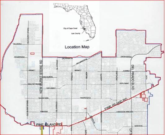
Figure 1. Map of the watershed.